


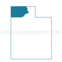
Mantua Unincorporated Voting District, Box Elder County, Utah
About
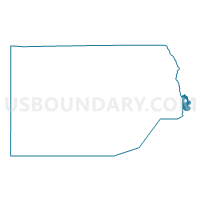
Outline

Summary
| Unique Area Identifier | 678466 |
| Name | Mantua Unincorporated Voting District |
| County | Box Elder County |
| State | Utah |
| Area (square miles) | 25.81 |
| Land Area (square miles) | 25.81 |
| Water Area (square miles) | 0.00 |
| % of Land Area | 100.00 |
| % of Water Area | 0.00 |
| Latitude of the Internal Point | 41.47368180 |
| Longtitude of the Internal Point | -111.93112900 |
Maps

Graphs
Select a template below for downloading or customizing gragh for Mantua Unincorporated Voting District, Box Elder County, Utah


Neighbors
Neighoring Voting District (by Name) Neighboring Voting District on the Map
- Brigham City 10 Voting District, Box Elder County, UT
- Brigham City 12 Voting District, Box Elder County, UT
- Brigham City 14 Voting District, Box Elder County, UT
- Brigham Northwest 02 Voting District, Box Elder County, UT
- Mantua Municipality Voting District, Box Elder County, UT
- Paradise Voting District, Cache County, UT
- Perry 1 Voting District, Box Elder County, UT
- Perry 4 Voting District, Box Elder County, UT
- South Willard Voting District, Box Elder County, UT
- Unpopulated Voting District, Cache County, UT
- Upper Valley 1 Voting District, Weber County, UT
- Wellsville 02 Voting District, Cache County, UT
Top 10 Neighboring County Subdivision (by Population) Neighboring County Subdivision on the Map
- Brigham City CCD, Box Elder County, UT (26,864)
- Hyrum CCD, Cache County, UT (9,799)
- Ogden Valley CCD, Weber County, UT (6,604)
- Wellsville CCD, Cache County, UT (6,117)
- East Cache CCD, Cache County, UT (105)
Top 10 Neighboring Place (by Population) Neighboring Place on the Map
Top 10 Neighboring Unified School District (by Population) Neighboring Unified School District on the Map
- Weber School District, UT (148,422)
- Cache School District, UT (64,634)
- Box Elder School District, UT (49,975)
Top 10 Neighboring State Legislative District Lower Chamber (by Population) Neighboring State Legislative District Lower Chamber on the Map
- State House District 5, UT (43,319)
- State House District 2, UT (34,283)
- State House District 8, UT (32,064)
Top 10 Neighboring State Legislative District Upper Chamber (by Population) Neighboring State Legislative District Upper Chamber on the Map
- State Senate District 17, UT (102,922)
- State Senate District 19, UT (91,855)
- State Senate District 25, UT (89,262)
Top 10 Neighboring 111th Congressional District (by Population) Neighboring 111th Congressional District on the Map
Top 10 Neighboring Census Tract (by Population) Neighboring Census Tract on the Map
- Census Tract 2101, Weber County, UT (6,942)
- Census Tract 13, Cache County, UT (6,117)
- Census Tract 9608.01, Box Elder County, UT (4,206)
- Census Tract 9606.02, Box Elder County, UT (2,429)
- Census Tract 15, Cache County, UT (2,038)
- Census Tract 9801, Cache County, UT (105)